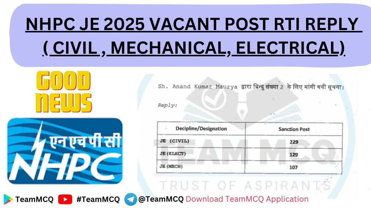
Explore the top 10 majestic mountains and passes in India that blend breathtaking geography with rich cultural heritage. A must-read for students and curious minds!
Introduction: Where Peaks Meet Pathways 🏔️
India’s diverse topography is not just a visual marvel—it’s a rich lesson in history, geography, and culture. Among its most awe-inspiring features are the mountains and passes in India that have shaped civilizations, trade routes, and even wars. From the snow-clad Himalayas in the north to the undulating Western Ghats in the south, each mountain range is a chapter in the story of natural wonder and human resilience.
But what truly links these towering landforms to movement and exchange are the mountain passes in India—natural corridors that have served as gateways for traders, pilgrims, warriors, and explorers across centuries. These passes are more than just routes; they are lifelines for remote communities and cultural connectors across terrains.
In this article, we’ll explore the most important mountains and passes in India, uncovering their geographical importance, historical influence, and cultural relevance. Whether you’re a student preparing for competitive exams or a curious learner fascinated by India’s landscape, understanding the mountains and passes in India will offer deeper insights into how geography shapes life, defense, and diversity across the subcontinent.
Major Mountain Ranges in India
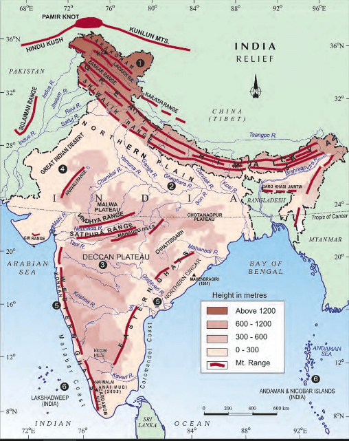
India is a land of immense geographical diversity, and its terrain is largely shaped by the mountain ranges in India. From the snow-capped peaks of the Himalayas in the north to the rolling hills of the Western and Eastern Ghats in the south, these majestic highlands influence the country’s climate, culture, rivers, and biodiversity. The major mountain ranges in India have played a pivotal role in the rise of ancient civilizations, spiritual traditions, and modern defense strategies.
These mountain ranges in India are more than just physical landforms—they are ecological lifelines and cultural guardians. They give birth to some of India’s mightiest rivers, nurture lush forests and rare wildlife, and provide sustenance to tribal and rural communities living in harmony with nature. From the ancient Aravalli Range, one of the oldest fold mountains on Earth, to the ever-rising Himalayas, each range contributes uniquely to India’s geological and cultural heritage.
For students, explorers, and geography enthusiasts, understanding the mountain ranges in India is essential to appreciating the nation’s natural landscape and its deep-rooted connection with history, ecology, and society.
🌄 List of Major Mountain Ranges in India
- The Himalayas – The Highest Mountain Range in India
- The Western Ghats – A Biodiversity Hub Among Mountain Ranges in India
- The Eastern Ghats – Ancient Yet Vital Mountain Ranges in India
- The Aravalli Range – Oldest Fold Mountains in India’s Mountain Ranges
- The Vindhya Range – A Unique Mountain Range in India’s Heartland
- The Satpura Range – Lesser-Known Mountain Ranges in India
- The Purvanchal Range – Eastern Extensions of Mountain Ranges in India
- The Karakoram Range – Snow-Capped Giants of Mountain Ranges in India
- The Shivalik Hills – Youngest Foothills in the Mountain Ranges of India
- The Nilgiri Hills – Confluence of Mountain Ranges in India
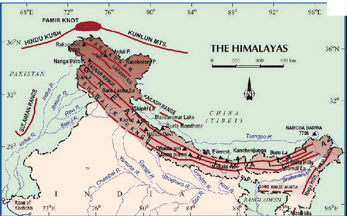
1. Himalayan Mountain Range – The Crown of Mountain Ranges in India
The Himalayan Mountain Range is the most iconic and highest among all in the Indian subcontinent. Stretching over 2,500 kilometers across five countries, including India, it serves as a majestic natural barrier in the north. This range is home to some of the world’s tallest peaks, including Mount Everest and Kanchenjunga, the latter being the highest in India at 8,586 meters.
Apart from its towering summits, the Himalayas are home to some of the most important mountain passes in India, which have historically served as gateways for trade, migration, and defense. Passes like Nathu La, Shipki La, and Jelep La continue to hold strategic significance, linking India to neighboring countries such as China, Bhutan, and Nepal.
From an educational and ecological standpoint, the Himalayas play a crucial role in shaping India’s geography, climate, and biodiversity. They influence the monsoon system, act as a natural climate barrier, and give rise to rivers like the Ganga, Yamuna, and Brahmaputra. Many mountain passes in India are located along these river valleys, making them vital for both travel and hydrological studies.
The Himalayan range is divided into three parallel zones: the Greater Himalayas (Himadri), the Lesser Himalayas (Himachal), and the Outer Himalayas (Shiwalik). These zones each contain important mountain passes in India, connecting valleys, remote villages, and pilgrimage sites like Kedarnath, Amarnath, and Badrinath.
For students, researchers, and adventurers alike, exploring the Himalayas offers a deeper understanding of how mountain passes in India have influenced history, culture, and geopolitics — making them an indispensable part of the nation’s natural and strategic legacy.
2. The Western Ghats – Biodiversity Hotspot of Mountain Ranges in India
The Western Ghats, also known as the Sahyadri Hills, are one of the oldest mountain ranges in India and a UNESCO World Heritage Site. Stretching along the western coast from Gujarat through Maharashtra, Goa, Karnataka, Kerala, and Tamil Nadu, this range runs parallel to the Arabian Sea for over 1,600 kilometers.
The Western Ghats are celebrated for their unparalleled biodiversity. Though not as tall as the Himalayas, their ecological importance is immense. With over 7,400 species of plants and animals, many of which are endemic, the Western Ghats play a vital role in maintaining environmental balance. This makes them a critical focus in the study of mountain ranges in India, particularly from an ecological and conservation perspective.
These hills are also the origin points for important rivers like the Godavari, Krishna, and Kaveri, which support agriculture and livelihoods across southern India. Educationally, students explore how the Western Ghats influence the monsoon pattern and rainfall distribution, making them key to India’s climate studies.
Culturally, the range is home to ancient temples, sacred groves, and tribal communities whose lives are deeply intertwined with nature. Peaks like Anamudi (2,695 m), the highest in southern India, are popular trekking and research destinations.
In essence, the Western Ghats represent the environmental heart of mountain ranges in India — a region where nature, culture, and science intersect powerfully.
3. The Eastern Ghats – Fragmented but Formidable: Mountains and Passes in India
The Eastern Ghats are a chain of discontinuous mountains stretching along the eastern coast of India, from Odisha through Andhra Pradesh to Tamil Nadu. While not as continuous or towering as the Western Ghats, they are an integral part of the mountain ranges and mountain passes in India, offering both geographical and cultural significance.
Unlike the Western Ghats, the Eastern Ghats are dissected by major rivers such as the Mahanadi, Godavari, Krishna, and Kaveri. These rivers cut across the hills and form crucial valleys and basins that have historically been used for travel, trade, and settlement—highlighting the importance of mountain passes in India for connecting inland and coastal regions.
The average elevation of the Eastern Ghats is lower, with peaks like Arma Konda in Andhra Pradesh reaching 1,680 meters. Yet, they remain critical in understanding the diverse landscape of mountains and passes in India. Their slopes are home to unique biodiversity, tribal communities like the Kondhs and Chenchus, and ancient pilgrimage sites such as Tirumala and Simhachalam.
One of the key geographical features of the Eastern Ghats is the presence of several important mountain passes in India, including the Nallamala Pass, Tirupati Ghat Road, and Araku Pass. These passes facilitate access between the coast and the interior plateau, underlining how mountain passes in India have always played a vital role in regional transportation and communication.
In modern times, these mountain passes in India continue to support tourism, trade, and pilgrimage in the Eastern Ghats region. From hill stations like Araku Valley to eco-sensitive zones and wildlife sanctuaries, these passes serve as gateways to natural and cultural heritage.
When we examine the larger picture of mountain passes in India, the Eastern Ghats prove that even fragmented and lower-elevation ranges can hold tremendous strategic, ecological, and historical value. They are a testament to the enduring role of geography in shaping civilizations and connecting cultures across time.
4. The Aravalli Range – Oldest Witness Among the Mountains and Passes in India
The Aravalli Range is one of the most ancient geological formations in the world, making it a unique entry in the study of mountains and passes in India. Spanning across Gujarat, Rajasthan, Haryana, and Delhi, this range dates back to the Proterozoic era — over 3 billion years ago!
Unlike the towering peaks of the Himalayas, the Aravallis are weathered and relatively low in height, with Guru Shikhar in Mount Abu being the highest point at 1,722 meters. Despite their age and reduced elevation, the Aravallis play a vital role in shaping the ecology and climate of northwestern India. They act as a climatic barrier, protecting regions like the Thar Desert from rapid desertification.
In ancient times, the Aravalli Range was home to several flourishing civilizations, including the Indus Valley and early Vedic cultures. Forts, temples, and battle sites across the range make it a living museum of India’s historical transitions.
While not known for many prominent mountain passes in India, the range has historically hosted several trade and pilgrimage routes. The passes helped link central and western India and supported the movement of goods and armies.
Today, efforts are being made to revive the ecological health of the Aravallis, which face threats from mining and deforestation. Conservation and afforestation projects aim to preserve this ancient shield of the Indian subcontinent.
In the broader context of mountains and passes in India, the Aravalli Range stands as a symbol of endurance, cultural memory, and ecological significance.
5. The Vindhya Range – The Mythic Divide in Mountains and Passes in India
The Vindhya Range stretches across central India, covering parts of Madhya Pradesh, Uttar Pradesh, and Bihar. Though not the highest among the mountains and passes in India, the Vindhyas hold immense geographical, cultural, and mythological significance. They form a natural boundary between North and South India, and this divide is deeply embedded in Indian traditions and texts.
Geologically, the Vindhyas consist of plateaus, hills, and ridges composed mainly of sandstone and quartzite. The range runs in an east-west direction and influences the course of rivers like the Chambal, Ken, Betwa, and Son. Though lower in elevation compared to the Himalayas or Western Ghats, the Vindhyas play a crucial role in shaping the drainage pattern and climate variation across central India.
In terms of historical significance, the Vindhya Range is often mentioned in ancient scriptures like the Ramayana and Mahabharata. It is also associated with trade routes and pilgrimage paths that connected the northern and southern regions of India.
While the Vindhyas may not be known for major mountain passes in India, they do feature several local passes used for centuries by traders, armies, and pilgrims. These routes helped integrate different regions and facilitated cultural exchange.
Today, the Vindhya Range is a focus area for conservation and tourism, with notable wildlife sanctuaries such as the Panna and Bandhavgarh national parks nestled within.
In the broader landscape of mountains and passes in India, the Vindhyas are a central thread that binds history, geography, and culture into one compelling narrative.
6. The Satpura Range – The Heartland Barrier of Mountains and Passes in India
The Satpura Range, nestled in central India, spans across Madhya Pradesh, Maharashtra, and Chhattisgarh. With its rugged terrain, deep valleys, and thick forests, the Satpuras form a vital part of the mountains and passes in India. They serve as a natural divide between the northern Indo-Gangetic plains and the southern Deccan Plateau, influencing both climate and topography.
Alongside the Vindhya Range, the Satpura hills shape India’s river systems in unique ways. Major rivers like the Narmada and Tapti originate in or flow through these ranges, moving westward—an exception to the typical eastward drainage of Indian rivers. This hydrological oddity makes the Satpura terrain a fascinating subject in the study of mountains and passes in India.
The range’s highest point, Dhupgarh (1,350 meters), is near Pachmarhi, a scenic hill station and UNESCO Biosphere Reserve. The Satpura region is rich in biodiversity, home to tiger reserves, national parks like Satpura and Pench, and dense sal and teak forests that act as ecological lungs of central India.
In terms of mountain passes in India, the Satpura range includes historic routes such as the Bori Pass and Deotala Pass. These were vital for ancient trade, migration, and even military campaigns, linking the plains with the deeper interiors of peninsular India.
Culturally, the Satpura region holds great significance. Tribal communities like the Gonds and Baigas have lived here for centuries, preserving unique lifestyles and oral traditions. The range is also renowned for prehistoric rock shelters and cave art, such as those found at Bhimbetka, a UNESCO World Heritage Site.
Altogether, the Satpura Range contributes richly to the geographical, ecological, and historical understanding of mountains and passes in India, and deserves greater attention in both academic and cultural discourse.
7. The Purvanchal Range – Eastern Extensions of Mountain Ranges in India
The Purvanchal Range forms the easternmost arm of the Himalayan system and is a vital part of the mountains and passes in India, especially shaping the geography of the northeastern states—Nagaland, Manipur, Mizoram, Tripura, and Arunachal Pradesh. Though less elevated than the Greater Himalayas, these ranges are biologically rich and ecologically vital.
Geologically composed of sedimentary rocks, the Purvanchals consist of parallel hill systems such as the Patkai Hills, Naga Hills, Mizo Hills (also called Lushai Hills), and Manipur Hills. Covered in thick forests, the region hosts diverse flora, fauna, and tribal cultures, making it a unique segment of the mountains and passes in India.
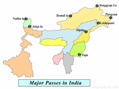
These hills form a natural boundary between India and its eastern neighbors, including Myanmar and China. The region’s strategic relevance is underscored by important mountain passes in India, like the Pangsau Pass in Arunachal Pradesh—historically a part of the Stilwell Road used during World War II for military and trade movements.
In the educational context of mountains and passes in India, the Purvanchal Range teaches us how topography can influence culture, climate, defense, and connectivity. The area enjoys a humid tropical climate, which sustains vibrant agriculture and some of the richest biodiversity in the country.
Often overlooked in popular narratives, the Purvanchals are a vital eastern chapter in India’s mountain heritage—bridging nature, security, and culture.
8. The Karakoram Range – Snow-Capped Giants of Mountain Ranges in India
The Karakoram Range is one of the most dramatic and high-altitude segments of the mountains and passes in India, dominating the northernmost frontiers of the subcontinent. Located mainly in the Union Territory of Ladakh and extending into Gilgit-Baltistan (currently under Pakistani control), this mighty range is famed for its towering peaks and glacial landscapes.
The centerpiece of the Karakoram is K2 (Mount Godwin-Austen) — the world’s second-highest peak at 8,611 meters, although it lies just beyond India’s current boundaries. Within Indian territory, the Saltoro Ridge and the Siachen Glacier — the world’s highest battlefield — highlight the strategic significance of the region in the context of mountains and passes in India.
Geologically younger than the Himalayas, the Karakoram features vast glaciers like the Baltoro and Siachen, which are essential sources of freshwater and influence the hydrology of northern India. These icy giants contribute significantly to sustaining rivers that nourish lower plains.
The range also includes some of the most critical mountain passes in India, such as Khardung La, one of the highest motorable passes in the world. These passes are lifelines for both military logistics and adventure tourism, connecting remote outposts to strategic zones.
In the broader scope of mountains and passes in India, the Karakoram stands out for its sheer height, military relevance, and ecological importance. It reminds us of the extreme environments India must navigate and protect — where nature, geography, and strategy converge in breathtaking fashion.
9. The Shivalik Hills – Youngest Foothills in the Mountain Ranges of India
The Shivalik Hills form the southernmost and youngest range in the mountains and passes in India, running parallel to the majestic Himalayas. Often referred to as the Outer Himalayas, the name “Shivalik” translates to “tresses of Shiva,” linking these hills with rich mythological and cultural significance.
Stretching across 2,400 km from Jammu & Kashmir to Arunachal Pradesh, the Shivalik Hills span a narrow belt of 10–50 km in width and rise to elevations between 600 to 1,200 meters. Composed mainly of loose sedimentary rocks like sandstone and conglomerates, this range was shaped by tectonic activity during the Tertiary period. Due to this, they remain geologically fragile and prone to landslides and erosion.
Despite their vulnerability, the Shivaliks are a biodiversity hotspot, home to important wildlife sanctuaries such as Rajaji National Park and Corbett Tiger Reserve. These forests not only protect flora and fauna but also act as ecological buffers in the broader scope of mountains and passes in India.
The Shivalik range also plays a crucial role in northern India’s hydrology, marking the source of several tributaries of the Ganga and Yamuna rivers. In many regions, it separates the fertile Indo-Gangetic plains from the towering Himalayas, influencing agriculture, settlements, and climate.
As one of the key components of the mountains and passes in India, the Shivalik Hills represent the dynamic and evolving nature of India’s topography. Studying this youthful range helps deepen our understanding of both geological history and cultural landscapes.
10. The Nilgiri Hills – Confluence of Mountain Ranges in India
Nestled in southern India, the Nilgiri Hills stand as a remarkable gem in the landscape of mountains and passes in India. The name “Nilgiri,” meaning “Blue Mountains,” comes from the bluish hue of the area — a result of dense eucalyptus forests and the rare Kurinji flowers that bloom once every 12 years, painting the hills in shades of violet-blue.
What truly makes the Nilgiris unique is their geographical significance. They form the confluence point of two major mountain systems — the Western Ghats and the Eastern Ghats — making this range ecologically and topographically vital. Located at the tri-junction of Tamil Nadu, Kerala, and Karnataka, the Nilgiri Hills rise to elevations between 2,000 to 2,600 meters, with Doddabetta Peak (2,637 m) being the highest.
Part of the Nilgiri Biosphere Reserve, this range is a hotspot of biodiversity, housing species like the Nilgiri Tahr, elephants, and tigers. It is also home to indigenous tribes such as the Todas, Kotas, and Kurumbas, whose lifestyles blend spirituality and sustainability. The landscape is dotted with tea gardens, cloud-kissed peaks, and charming hill towns like Ooty and Coonoor.
Adding to its charm is the Nilgiri Mountain Railway, a UNESCO World Heritage Site, which showcases human ingenuity in traversing rugged highlands — a recurring theme in the mountains and passes in India.
The Nilgiri Hills beautifully merge natural beauty, cultural history, and strategic geography, making them an essential part of India’s mountainous story.
Major Mountain Ranges in India – Summary Table
| Mountain Range | Key Features | Cultural Significance |
|---|---|---|
| The Himalayas | Highest mountain range in the world; includes Mt. Everest and Kanchenjunga; source of major rivers | Sacred in Hinduism and Buddhism; home to pilgrimage sites like Kedarnath, Badrinath, and Amarnath |
| The Western Ghats | UNESCO World Heritage Site; high biodiversity; origin of rivers like Godavari and Krishna | Inhabited by tribal communities; houses ancient temples like Sabarimala |
| The Eastern Ghats | Discontinuous, older range; runs along eastern coast; lower elevation than Western Ghats | Region of ancient temple architecture (e.g., Tirupati); tribal and agricultural heritage |
| The Aravalli Range | One of the oldest fold mountains; semi-arid terrain; source of Banas and Sabarmati rivers | Region of historical forts and cities like Udaipur and Jaipur |
| The Vindhya Range | Acts as a natural divide between North and South India; moderate height | Mentioned in Ramayana and Mahabharata; significant in cultural geography |
| The Satpura Range | Forest-rich and rugged terrain; important for wildlife like in Satpura National Park | Tribal settlements and eco-tourism importance in Madhya Pradesh |
| The Purvanchal Range | Extension of the Himalayas in the northeast; highly forested and rugged | Home to unique tribal cultures and biodiversity in states like Nagaland and Mizoram |
| The Karakoram Range | Glacial landscape; includes Siachen Glacier and K2 (India’s highest peak under control) | Border significance and mountaineering importance; harsh and strategic |
| The Shivalik Hills | Youngest foothills of the Himalayas; runs parallel to main ranges | Fertile valleys and ancient cave sites; significant to archaeological studies |
| The Nilgiri Hills | Junction of Western and Eastern Ghats; tea-growing region; Doddabetta peak | Nilgiri tribes like Todas; UNESCO heritage railway; eco-tourism and biodiversity |
Mountain Passes in India – Gateways Through the Mountains
Mountain Passes in India are narrow and strategic routes that cut through rugged and often snow-covered mountain ranges in India, acting as natural corridors between remote regions. These mountain passes in India have historically been crucial in shaping the country’s geography, trade, defense, and cultural exchanges. From ancient silk routes to modern military logistics, these high-altitude passes have enabled travelers, traders, pilgrims, and armies to traverse the subcontinent’s most challenging terrain.
Found across major Indian mountain ranges such as the Himalayas, Western Ghats, and Eastern Ghats, many of these passes rise thousands of meters above sea level. Their elevation makes them breathtaking in scenery but also treacherous to cross, especially in winter. Passes like Khardung La, Nathu La, and Zoji La are iconic examples of mountain passes in India that combine extreme altitudes with strategic significance.
Militarily, mountain passes in India are lifelines along sensitive international borders with China, Pakistan, and Nepal, and are heavily guarded by the Indian Armed Forces. In addition to their military importance, these passes also act as cultural bridges, facilitating the exchange of languages, foods, textiles, and traditions between once-isolated communities. Religious pilgrimages through passes like the Amarnath Yatra route further underline their spiritual and cultural relevance.
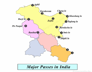
Most important Mountain Passes in India
| Mountain Pass | Location | Range | Significance |
|---|---|---|---|
| Zoji La | Jammu & Kashmir – connects Srinagar to Leh | Western Himalayas | Strategic military route; remains snow-covered for part of the year |
| Nathu La | Sikkim – connects India to Tibet | Eastern Himalayas | Trade route; reopened in 2006; part of the ancient Silk Route |
| Khardung La | Ladakh – gateway to Nubra Valley | Ladakh Range | One of the highest motorable roads in the world |
| Shipki La | Himachal Pradesh – trade route with Tibet | Sutlej Valley | Entry point of the Sutlej River into India |
| Rohtang Pass | Himachal Pradesh – connects Manali to Lahaul-Spiti | Pir Panjal | Major tourist attraction; now bypassed by the Atal Tunnel |
| Banihal Pass | Jammu & Kashmir – links Jammu to Srinagar | Pir Panjal | Crucial for movement between Jammu and Kashmir |
| Jalori Pass | Himachal Pradesh | Lesser Himalayas | Scenic trekking route; featured in Bollywood films |
| Thang La | Ladakh | Zaskar Range | High-altitude military post |
| Bum La | Arunachal Pradesh – near Tawang | Eastern Himalayas | Indo-China border post; historic WW2 route |
| Lipulekh Pass | Uttarakhand – connects India with Tibet | Kumaon Himalayas | Used for Kailash Mansarovar Yatra; strategic and religious significance |
🗺️ Recently Highlighted Mountain Passes in India (Updated List)
| Mountain Pass | State/UT | Range | Recent Significance / Development |
|---|---|---|---|
| Sela Pass | Arunachal Pradesh | Eastern Himalayas | New Sela Tunnel inaugurated to ensure all-weather connectivity to Tawang. |
| Tanglang La | Ladakh | Zanskar Range | Part of the Leh-Manali Highway; crucial for defense logistics. |
| Rezang La | Ladakh | Kailash Range | Site of 1962 war valor; upgraded memorial inaugurated recently 🇮🇳 |
| Baralacha La | Himachal–Ladakh Border | Zanskar Range | On Manali-Leh route; frequently updated for smoother military access. |
| Debsa Pass | Himachal Pradesh | Pir Panjal | Newer trekking route; gaining importance for eco-tourism and local trade. |
| Nechiphu Pass | Arunachal Pradesh | Lesser Himalayas | Part of Trans-Arunachal Highway; being upgraded for better military mobility. |
| Zemithang Pass | Arunachal Pradesh | Eastern Himalayas | Near China border; emerging in discussions due to border developments. |
Conclusion
Mountains and Passes in India are more than just geographical formations — they are the towering sentinels of our natural heritage, the silent storytellers of India’s ancient past, and the protectors of ecological and strategic wealth. From the snow-laden Himalayas and Karakoram Range in the north to the lush Western Ghats and Nilgiri Hills in the south, each range reflects the geological brilliance and cultural pulse of India.
Likewise, mountain passes in India—like Rohtang Pass, Bomdila Pass, Nathu La, and Zoji La—have been historic arteries of movement. These narrow paths, carved by nature and tread by time, have connected civilizations, opened trade routes, hosted spiritual journeys, and stood at the frontlines of defense. Their strategic value remains undeniable even in modern geopolitics, especially in border regions where accessibility is both a logistical marvel and a national imperative.
Beyond defense and trade, mountains and passes in India are custodians of India’s vibrant biodiversity and indigenous cultures. Tribal communities, rare flora and fauna, and sacred shrines all find sanctuary in these highlands. Festivals, folklore, and traditions rooted in these terrains enrich India’s intangible heritage.
Understanding and preserving the mountains and passes in India isn’t just a matter of pride — it’s essential for sustainable development, climate resilience, and cultural continuity. As we ascend each ridge or cross every pass, we connect not only with the land but also with centuries of human endeavor, belief, and perseverance.
Let every summit echo with respect and every pass whisper a legacy. For in these majestic elevations lie the roots of India’s soul and the pathways to its future.

MCQ QUESTIONS WITH EXPLANATION
1. Which of the following is the highest motorable mountain pass in India?
A) Zoji La
B) Rohtang Pass
C) Khardung La ✅
D) Nathu La
📘 Explanation: Khardung La in Ladakh is one of the highest motorable roads in the world at around 18,000 ft.
2. Nathu La Pass connects India to which neighboring country?
A) Nepal
B) Bhutan
C) Myanmar
D) China ✅
📘 Explanation: Nathu La connects Sikkim in India to Tibet, China. It’s a historic Silk Route pass.
3. Which mountain pass is located in Jammu & Kashmir and connects Srinagar to Leh?
A) Bara Lacha La
B) Shipki La
C) Zoji La ✅
D) Lipulekh Pass
📘 Explanation: Zoji La is a key strategic pass that connects Kashmir Valley with Ladakh.
4. The Shipki La pass is located in which Indian state?
A) Arunachal Pradesh
B) Sikkim
C) Himachal Pradesh ✅
D) Uttarakhand
📘 Explanation: Shipki La in Himachal Pradesh connects India to Tibet and is used for Indo-China trade.
5. Which pass is famous for connecting Manali to Leh and serves as a major trekking and biking route?
A) Nathu La
B) Rohtang Pass ✅
C) Zoji La
D) Bomdi La
📘 Explanation: Rohtang Pass is a scenic and strategic route on the Manali-Leh highway.
6. Lipulekh Pass is significant for which Hindu pilgrimage?
A) Amarnath Yatra
B) Vaishno Devi
C) Kailash Mansarovar ✅
D) Char Dham Yatra
📘 Explanation: Lipulekh Pass in Uttarakhand is the gateway to the Kailash Mansarovar Yatra.
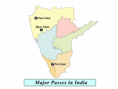
7. The Palghat Gap connects which two Indian states?
A) Kerala and Karnataka
B) Tamil Nadu and Andhra Pradesh
C) Kerala and Tamil Nadu ✅
D) Maharashtra and Kerala
📘 Explanation: Palghat Gap in the Western Ghats is a low mountain pass that links Kerala to Tamil Nadu.
8. Bomdi La Pass lies in which northeastern Indian state?
A) Assam
B) Arunachal Pradesh ✅
C) Nagaland
D) Meghalaya
📘 Explanation: Bomdi La is a key pass in Arunachal Pradesh, close to the India-China border.
9. Jelep La Pass is located in which region of India?
A) Ladakh
B) Sikkim ✅
C) Himachal Pradesh
D) Arunachal Pradesh
📘 Explanation: Jelep La is an important pass between Sikkim and the Chumbi Valley in Tibet.
10. Which pass acts as a natural divide between the Eastern and Western Ghats?
A) Bhor Ghat
B) Palghat Gap ✅
C) Thal Ghat
D) Banihal Pass
📘 Explanation: Palghat Gap is the only low-lying break in the long stretch of the Western Ghats.